


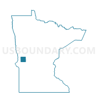
Delaware Twp. Voting District, Grant County, Minnesota
About
Outline

Summary
| Unique Area Identifier | 602056 |
| Name | Delaware Twp. Voting District |
| County | Grant County |
| State | Minnesota |
| Area (square miles) | 36.25 |
| Land Area (square miles) | 35.54 |
| Water Area (square miles) | 0.72 |
| % of Land Area | 98.02 |
| % of Water Area | 1.98 |
| Latitude of the Internal Point | 45.89209190 |
| Longtitude of the Internal Point | -96.06505780 |
Maps

Graphs
Select a template below for downloading or customizing gragh for Delaware Twp. Voting District, Grant County, Minnesota


Neighbors
Neighoring Voting District (by Name) Neighboring Voting District on the Map
- Elbow Lake Twp. Voting District, Grant County, MN
- Gorton Twp. Voting District, Grant County, MN
- Lien Twp. Voting District, Grant County, MN
- Logan Twp. Voting District, Grant County, MN
- Macsville Twp. Voting District, Grant County, MN
- Roseville Twp. Voting District, Grant County, MN
- Sanford Twp. Voting District, Grant County, MN
Top 10 Neighboring County Subdivision (by Population) Neighboring County Subdivision on the Map
- Sanford township, Grant County, MN (153)
- Elbow Lake township, Grant County, MN (141)
- Roseville township, Grant County, MN (124)
- Macsville township, Grant County, MN (114)
- Lien township, Grant County, MN (111)
- Delaware township, Grant County, MN (102)
- Logan township, Grant County, MN (93)
- Gorton township, Grant County, MN (49)